Walking
Pages in Walking
- 1. You are here: Self guided walks
- 2. Information on walking
1. Self guided walks
Our borough has lots of beautiful green spaces, providing lots of walking opportunities for anyone looking to get outside and get active.
Banstead Countryside Walk
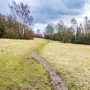 A circular walk around the Banstead countryside, close to Chipstead. This beautiful route goes through chalk grassland, mixed woodlands and open farmland, all rich habitats for a range of wildlife and flowers.
- Start/Finish - Holly Lane free car park (CR5 3NR)
- Distance - 8.5km (5 miles)
- Time - Allow 3 hours
- Difficulty - Challenging terrain (steep climbs and descents)
- Access - challenging (not suitable for wheelchairs and pushchairs due gates and steps)
Download map and directions for Banstead Countryside walk (PDF)
Banstead Woods Nature Trail
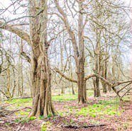 A gently undulating circular walk discovering the hidden secrets and natural wonders of Banstead Woods, 250 acres of ancient woodland. Banstead Woods' recorded history stretches back to the time of the Domesday Book in 1086. Look out for the Narnia Trail. Great for bluebells.
- Start/Finish - Holly Lane free car park (CR5 3NR)
- Distance - 5 km (3 miles)
- Time - Allow 2 hours
- Difficulty - Easy terrain (rough ground which can be muddy. Gates and stiles)
- Access - challenging (not suitable for wheelchairs and pushchairs due slopes and kissing gates)
Download map and directions for Banstead Woods Nature trail (PDF)
Discover Gatton
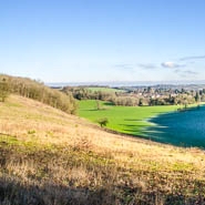 An easy circular walk around Gatton Park, a beautiful area of parkland designed by Lancelot Capability Brown, giving you a glimpse into its diverse history.
- Start/Finish - Wray Lane free car park (RH2 0HX)
- Distance - 3.5km (2 miles)
- Time - Allow 1.5 hours
- Difficulty - moderate terrain (some inclines, most of the route follows stone tracks the woodland can be muddy)
- Access - moderate (route is suitable for rugged pushchairs and disability buggies Easter to October)
Download map and directions for Discover Gatton walk (PDF)
East Horley Circular
 A flat circular walk taking you on a journey through time where new meets old and built up areas merge with farmland, streams and woodland. You'll encounter World War II pillboxes, hints of the tanning industry and the mysterious site of Thunderfield Castle.
- Start/Finish - Outside The Farmhouse Pub (RH6 8PB)
- Distance - 9.5km (6 miles)
- Time - Allow 3 hours
- Difficulty - Moderate terrain (rough ground which can be muddy. Gates and stiles)
- Access - challenging (not suitable for wheelchairs and pushchairs due gates and stiles)
Download map and directions for East Horley Circular walk (PDF)
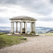
Reigate Hill
Enjoy an exhilarating walk across Reigate Hill and learn how man has influenced the history on the hill.
- Start/Finish - National Trust Margery Lane car park (KT20 7BD) Non-members charge
- Distance - 5.28km (3.3 miles)
- Time - Allow 2 hours
- Difficulty - Moderate terrain (fairly level paths with steep descent on a chalk path)
- Access - challenging (not suitable for wheelchairs and pushchairs due to steps)
Map and directions for Reigate Hill walk (National Trust website)
Reigate and Colley Hill
 An easy access walk along the North Downs Way with spectacular views, taking in Colley Hill and Reigate Hill and visiting the attractions of Reigate Fort and the Inglis Memorial.
- Start/Finish - National Trust Margery Lane car park (KT20 7BD) Non-members charge
- Distance - 4.5km (3 miles)
- Time - Allow 1.5 hours
- Difficulty - Easy terrain (wide surfaced paths throughout, some a little uneven. A few gentle to moderate gradients)
- Access - moderate (route is suitable for rugged pushchairs and disability buggies)
Download map and directions for Reigate and Colley Hill walk (PDF)
Reigate Mills and Pillboxes
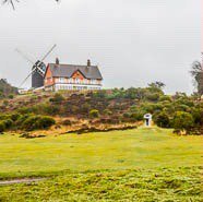 An enjoyable circular walk from Reigate Heath, passing Reigate Heath windmill, Wonham Mill and pillboxes built during the Second World War. There are good views along the walk to the North Downs.
- Start/Finish - Reigate Heath bus stop (RH2 8AB)
- Distance - 6.5km (4 miles)
- Time - Allow 2 hours
- Difficulty - Moderate terrain (gentle gradients but paths are mostly unmade so can be muddy)
- Access - challenging (not suitable for wheelchairs and pushchairs due kissing gates and stiles)
Download map and directions for Reigate Mills and Pillboxes walk (PDF)
Reigate Town History Treasure Trail
Follow the historic treasure trail through Reigate town centre which was published in 2013 as part of the 150th anniversary celebrations of the Royal Charter of 1863, which made Reigate into a Municipal Borough.
- Start/Finish - Starts in Priory Park (RH2 7RL) and finishes at Reigate castle (RH2 0AP)
- Time - Allow 1 hour
- Difficulty - Moderate terrain (fairly level easy paths until the final part of the trail, cobbled alley and Donkey Steps)
- Access - challenging (final part of the trail not suitable for wheelchairs and pushchairs due to steep steps)
Download map and directions for Reigate Town History Treasure Trail (PDF)